
Hundreds of new homes could be built on former brownfield land after 24 sites were identified by Sefton Council.
The land earmarked for development could see up to 915 new properties being built on former factories, schools, railway land, churches, pubs, dairies, farms and other uses.
They include the potential for: 65 new builds on the former Kew Park and Ride site in Southport; 100 homes at the former Former Johnsons Cleaners site in Bootle; 187 homes at the former Bootle Gasworks; 63 homes at the former Bootle High School; and 10 homes on the former Ambulance Station at Formby.
Sites which weren’t included in the Register include the former Ainsdale High School and the Mecca Bingo building on Lord Street, which closed earlier this month.
The official ‘Brownfield Register’ has now been approved by councillors, with the hope of attracting developers to convert derelict sites into new uses.
In his report, Chief Planning Officer Neil Mackie said: “The Brownfield Register will identify brownfield sites in Sefton that are suitable for housing development. All sites to be included in the Register will need to be suitable, available and achievable.
“The Brownfield Land Register could highlight ‘difficult to develop’ sites that may be available. “Inclusion on the Register may help support bids for funding to support the development of those sites.
“Any site included in the Register will need to be suitable for housing development (likely to comply with planning policies), available for development (have a willing landowner) and should be realistically achievable (i.e. likely to be financially viable and have no other constraints that would prevent it coming forward).
“Maintaining an up-to-date Brownfield Register will be an ongoing piece of work. We will continue to carry out an annual ‘call for sites’ and any suitable sites will be added to the SHLAA and our 5 year land supply.”
The 24 sites on the Sefton Council Brownfield Register are:
1 – Former Kew Park and Ride, Crowland Street, Southport – 65 homes
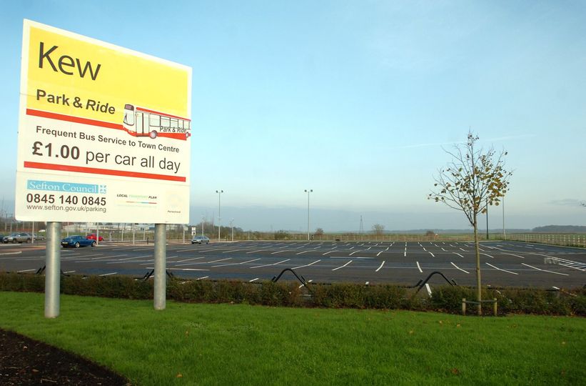
Part of Local Plan allocation MN2.5. Former and now disused park and ride site. Should be built in conjunction with wider allocation. Not permissioned.
2 – Land to the rear of 91 -97B, Eastbank Street, Southport – 10 homes
Commercial buildings on the edge of Southport Town Centre. Expired permission.
3 – Land West of Lynton Road, Lynton Road, Southport – 20 homes
Former railway land between the railway and housing. Not permissioned.
4 – 18 -20, Granville Road, Southport – 8 homes
Site of detached properties and rear gardens. Various permissions – Partial brownfield. The site is in a Conservation Area and as such design standards apply. Minimum figure based on there being a number of apartments.
5 – 101, Liverpool Road, Maghull & Aintree – 12 homes
Single dwelling house with planning permission. Permissioned. Permission DC/2016/02394 for 12 apartments. Figure of 12 reflects apartments.
6 – Land South of Spencers Lane, Spencers Lane, Maghull & Aintree – 15 homes
Area of hardstanding to the rear of existing properties. Adjacent to the M57. Not permissioned. Backs onto motorway. Local Plan allocation MN2.33. Minimum number of dwellings figure is 15 to reflect the Local Plan Appendix 1.
7 – Former Litherland Methodist Church, Wilsons Lane, Netherton – 7 homes
Permissioned. DC/2016/01227 – approval for 7 dwellings.
8 – Kirkstone Hotel, Moss Lane, Netherton – 14 homes
Former public house site. Permissioned. Former pub. DC/2014/01024 – for 14 two bedroom apartments. Figure of 14 is based on the existing permissionand apartments.
9 – Mushroom Farm, 8 -10, Cable Street, Formby – 5 homes
Partly developed site. Nearly built out but last part is long term stalled. Left over area of land capable of 5 dwellings.
10 – Ambulance Station, Church Road, Formby – 10 homes
Not permissioned. DC/2014/01573 – 10 apartments. Figure of 10 is based on apartments. Permission expired.
11 – Former Dairy, 5, Marsh Brows, Formby – 5 homes
Permissioned. Former dairy site.
12 – Factory building, Sandy Lane, Crosby & Hightown – 46 homes
Permissioned. Large industrial unit in the centre of the Sandy Road Industrial Estate. Adjacent to housing, other industrial uses, and the railway line.
13 – Church Hall, 17 Mersey Road, Crosby & Hightown – 5 homes
Permissioned. Approved for 5 homes (DC/2015/00167). Former church hall.
14 – Former Johnsons Cleaners, Mildmay Road, Bootle – 100 homes
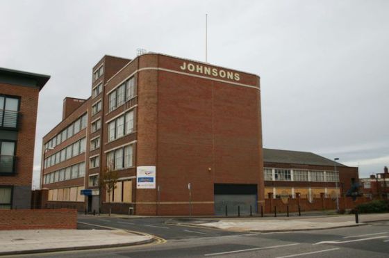
Permissioned. Previously developed former Johnsons Cleaners site in a residential area. Former Johnsons site. Has permission and suitable for development. Has scope for mixed use with limited retail subject to NPPF sequential and impact tests. Minimum figure assumes a high number of apartments.
15 – Z Blocks Site A, Buckley Hill Lane, Netherton – 50 homes
Not permissioned. Cleared site that contained former post war apartment blocks. Part of Local Plan allocation (MN2.36). Undeveloped and with no permission.
16 – Bootle Gasworks, Litherland Road, Bootle – 187 homes.
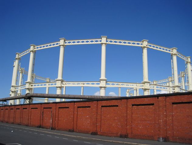
Not permissioned. Large disused former gas works. The site is a allocated in the Local Plan as a Regeneration Opportunity Site. This could make a very good housing site that would be suitable with the surroundings. The site is heavily contaminated and the site will have to be considered as a whole.
17 – 503 – 509, Hawthorne Road, Bootle – 119 homes
Permissioned. Former industrial units in poor condition. Adjacent to the canal. Potential for some contamination. Next to Canal where issues may need to be addressed. Planning permission for mixed use residential and retail. (2021)
18 – Former People’s site, Linacre Lane, Bootle – 110 homes
Cleared and levelled brownfield site. Has contamination issues that impact upon viability. Council owned Local Plan site. (2021).
19 – Former Rawson Road Primary School, Rawson Road, Bootle – 10 homes.
Not permissioned. Former school site, now cleared. Adjacent to two major roads. Most of the site is brownfield. (2021).
20 – Land at Former Bootle High School, Brown’s Lane, Bootle – 63 homes
Site of former school which has been demolished and cleared. Not permissioned. Local Plan allocation. Council owned brownfield site. (2021).
21 – Land at Pendle Drive, Pendle Drive, Bootle – 29 homes
Not permissioned. Large, partially cleared site. Local Plan allocation (MN2.38) suitable for development. Mostly brownfield but with some of the site is greenfield. (2021).
22 – Land adj to St Monica’s Parochial, Stewart Avenue, Bootle – 10 homes
Not permissioned. Vacant land. DC/2015/01679- permission for 13 flats. Current application for care home (DC/2020/00807) (2021).
23 – 2, Well Lane, Bootle – 10 homes
Permissioned. Former industrial premises in a predominantly residential area. DC/2018/00357 (2021).
24 – Former Service Station, 146, Park Lane, Netherton – 5 homes
Permissioned. Former service station site. The figure of 10 is for flats and was approved in the recent planning application (DC/2016/02117). More up to date application (DC/2020/02475).
Do you have a story for Stand Up For Southport? Please message Andrew Brown via Facebook here or email me at: mediaandrewbrown@gmail.com